Example
Land & water taught by AR sandbox
< Summary of our activities>
We made our AR sandbox by ourselves, and it is on display in the exhibition room (open on weekdays) at the Institute for Planetary Materials in Misasa, Tottori Prefecture. It is used for training of local elementary, junior high, and high school students, and for tours of the laboratory by the general public. We have lent it to a museum for special exhibition. The exhibit is a fun and interactive way to learn about topography, contour lines, watershed and the distribution and movement of water on land.Other exhibits in the gallery include rock thin section viewed through a polarizing microscope, in-situ observation of high-pressure ice, a real multi-anvil high-pressure device, a display of mineral structures, a cloud chamber for visualizing radiation, and displays of rocks, minerals, and meteorites.
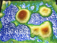
Contour lines and colors are projected according to the height of the sand in the sand box. The water moves to a lower position. When the terrain is changed, it is updated in real time.
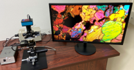
A display of rock thin section using a polarizing microscope. The thin section is automatically rotated, and you can see the beautiful interference color changes.
Representative